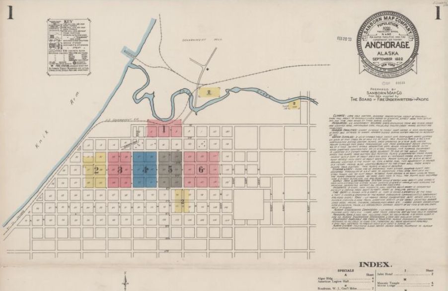
Sanborn Maps as a Genealogy Tool
If your family lived in an urban area of the U.S. after
1867, you just may be able to locate their home or place of business on a
Sanborn map. These maps depict the
commercial, industrial, and residential sections of some twelve thousand cities
and towns providing a valuable research tool for anyone with a personal
connection to a building.
Many people are not familiar with the Sanborn name because they specialized in creating maps for the fire insurance industry. What was once a tool for determining the degree of fire hazard associated with a property has now become a valuable tool for genealogists who seek to understand the environment in which their ancestors inhabited.
The maps themselves are large-scale lithographed street plans at a scale of 50 feet to one inch on 21 x 25 inches sheets of paper. The maps were published in bound volumes, which were updated as needed until a subsequent volume was produced.
These maps reveal details of buildings that could assist a family researcher in their work including size, shape, and construction of dwellings, commercial buildings, and factories as well as fire walls, locations of windows and doors, sprinkler systems, and types of roofs.
History of Sanborn Maps
Before these maps were available, insurance underwriters
had to visit every property under consideration for fire coverage. As insurance companies increased their
service areas, it became no longer practical to send someone out to every
insurable property to assess risk.
Daniel Alfred Sanborn, a civil engineer and surveyor, saw a lucrative opportunity beginning to blossom and created a company to fill the need. Once available, these maps allowed the process of underwriting to take place in an office. Subscribing insurance companies helped share the high cost of creating the maps and helped to make the Sanborn Map Company an industry leader.
The last Sanborn fire maps were published in 1977, after US insurance companies stopped using maps for underwriting. The Sanborn Company still exists today, but has adjusted their focus towards the capturing, analyzing and manipulation of geographic data.
Library of Congress Sanborn Map Collection
http://www.loc.gov/collections/sanborn-maps
The Library of Congress holdings include the largest collection of fire insurance maps created by the Sanborn Company. Their collection includes some fifty thousand editions of fire insurance maps comprising an estimated seven hundred thousand individual sheets.
Not all maps are currently available in their digital form,
but efforts are underway to get their entire collection online within the next
few years.
Read related articles: Tricks of the
Trade
Recent Articles
Colorize your Genealogy B&W Photographs for Free
How to Overcome Procrastination Today
5 Genealogy Books that Will Make You an Expert
Using Historical Maps for Genealogy
Researching North Dakota Ancestors
Most Popular
Leading Causes of 1800’s Infant Mortality
Download Free Genealogy Charts
Exploring FamilySearch’s Facial Recognition Tool
One-Step Genealogy with Stephen Morse
Searching Castle Garden Passenger Lists
Researching Last Name Meanings and Origins
The Real Truth about Family Coat of Arms
When to Employ Reverse Genealogy
Researching Ancestors Using Obituaries
Using Cyndi’s List for Genealogy Research
FamilySearch: A Necessity for all Genealogists
Ancestry.com: Getting the Most from your Subscription
Article Archive
Getting Started (19)
Record Sources (24)
Tricks of Trade (33)
Best Practices (29)
Brick Walls (20)
Family Story (21)
Product Reviews (21)


Beginner
Guide
Genealogy Quick Start Guide for Beginners
Applying the Genealogy Proof Standard to your Research
Google Genealogy Research Toolbox
Find Records
Researching Ancestors through Military Records
Using the National Archives (NARA) for Genealogy Research
Using U.S. Census Records
Canadian Genealogy Research using the Internet
Tips
Genealogy Source Citations Made Easy
Listening to Genealogy Podcasts Made Easy