Using the Newberry Atlas of Historical County Boundaries
Nobody likes to waste their precious time when researching county based genealogy records including vitals, wills/probate and deeds of land transfers. This article covers the use of a valuable online resource called the Newberry Atlas of Historical County Boundaries and what it can do to help you find the correct counties in which to search for your records.
The Problem
Those new to genealogy may not realize that county boundaries can and often do change with the passing of time, which can cause them to search for records in the wrong county. For example, you may know the town and county where your ancestors lived, but still you can’t find their records in that county! What gives? Was the record destroyed or misplaced?
What often happens is that county boundaries changed, over time, and the records are really stored in a neighboring county. This situation can be especially frustrating when you are traveling on your own dime to courthouses in distant places with a limited time-frame to complete your research.
Searching for a record in the wrong county, due to boundary changes, is a common occurrence and is certainly to be avoided. For decades, professional genealogists have come to count on the Newberry Atlas of Historical County Boundaries to break through county boundary brick wall issues.
History of the Newberry Atlas of Historical County Boundaries
According to the Newberry website, the Atlas was conceived in 1975 after historians working on the Atlas of Early American History (1976) at the Newberry Library discovered the nearly complete lack of reliable maps of American counties in the revolutionary and early national periods.
The awesome folks at the Newberry Library painstakingly researched all the county boundary changes for all 50 states and made their incredible work available to the public. The Atlas describes and maps every change in the boundaries of all United States counties from the early 1600s to 2000 with no known holes in their coverage. Early versions of the Atlas were published in paper form and later the website we are familiar with today was created.
Using the Atlas Website
The Atlas website can be accessed at the following URL: http://publications.newberry.org/ahcbp/
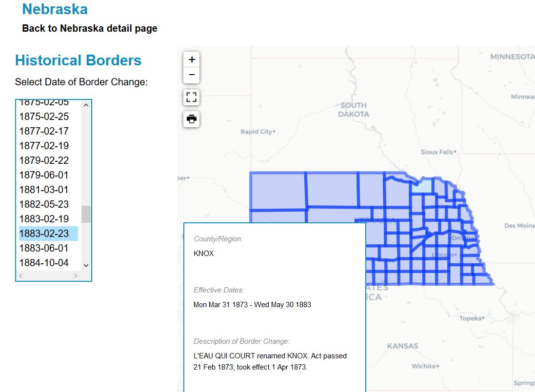
From the Atlas homepage, click the state you are searching in, then click “View Interactive Map” and choose a date from the drop-down list reflecting the time-period of the record you are interested in.
The result is a visual map of county boundaries as they were during the time your ancestors lived there. This interactive map will help you to discover what county your ancestors belonged to at the time the record was created. Perhaps you’ll discover you should be looking for the record in a parent county (one that existed there before the current county) or in a successor county later carved out of that one.
See the image at the top of this article for an Atlas example of Knox county, Nebraska in 1883.
Conclusion
The Newberry atlas is a great online resource for quickly
researching historical county boundaries in the U.S. By doing a bit of research ahead of time with
the online Atlas, you can save yourself a lot of frustration and wasted time
looking in the wrong counties for records.
Read related articles: Breaking Through
Brick Walls
Recent Articles
Colorize your Genealogy B&W Photographs for Free
How to Overcome Procrastination Today
5 Genealogy Books that Will Make You an Expert
Using Historical Maps for Genealogy
Researching North Dakota Ancestors
Most Popular
Leading Causes of 1800’s Infant Mortality
Download Free Genealogy Charts
Exploring FamilySearch’s Facial Recognition Tool
One-Step Genealogy with Stephen Morse
Searching Castle Garden Passenger Lists
Researching Last Name Meanings and Origins
The Real Truth about Family Coat of Arms
When to Employ Reverse Genealogy
Researching Ancestors Using Obituaries
Using Cyndi’s List for Genealogy Research
FamilySearch: A Necessity for all Genealogists
Ancestry.com: Getting the Most from your Subscription
Article Archive
Getting Started (19)
Record Sources (24)
Tricks of Trade (33)
Best Practices (29)
Brick Walls (20)
Family Story (21)
Product Reviews (21)


Beginner
Guide
Genealogy Quick Start Guide for Beginners
Applying the Genealogy Proof Standard to your Research
Google Genealogy Research Toolbox
Find Records
Researching Ancestors through Military Records
Using the National Archives (NARA) for Genealogy Research
Using U.S. Census Records
Canadian Genealogy Research using the Internet
Tips
Genealogy Source Citations Made Easy
Listening to Genealogy Podcasts Made Easy